
Evacuation orders issued for multiple regions in northern B.C. as hundreds of wildfires burn
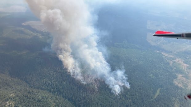
The Tintagel Wildfire east of Burns Lake is pictured in this aerial image. The fire led to evacuation orders and alerts on Saturday, as hundreds of fires continue to burn across B.C. (B.C. Wildfire Service/Twitter)A regional district in northern B.C. has issued multiple evacuation orders due to the risks from the Tsah Creek, Finger Lake and Parrot Lookout wildfires.The Regional District of Bulkley-Nechako (RDBN) says the danger posed by the Tsah Creek wildfire has prompted the evacuation order for all properties on either side of Highway 27 in the vicinity of Echo Lake and Bearcub forest service road. An evacuation alert was also issued Sunday morning for properties further north along the highway.Late Saturday night, the Ministry of Transportation and Infrastructure closed a 12-kilometre stretch of the Highway 27 corridor between Blue Mountain Road and Kenner Road as a precautionary measure after the wildfire breached control lines.The road was reopened early on Sunday morning, accord

A regional district in northern B.C. has issued multiple evacuation orders due to the risks from the Tsah Creek, Finger Lake and Parrot Lookout wildfires.
The Regional District of Bulkley-Nechako (RDBN) says the danger posed by the Tsah Creek wildfire has prompted the evacuation order for all properties on either side of Highway 27 in the vicinity of Echo Lake and Bearcub forest service road. An evacuation alert was also issued Sunday morning for properties further north along the highway.
Late Saturday night, the Ministry of Transportation and Infrastructure closed a 12-kilometre stretch of the Highway 27 corridor between Blue Mountain Road and Kenner Road as a precautionary measure after the wildfire breached control lines.
The road was reopened early on Sunday morning, according to DriveBC, which says that limited visibility is likely in the area due to dense smoke.
✅CLEAR - #BCHwy27 The road is now open in both directions between Blue Mountain Rd and Kenner Rd after being closed due to a wildfire. Travelers can expect limited visibility with dense smoke in the area and are advised to drive with caution. #Vanderhoof#FortStJames
—@DriveBCIt is just the latest evacuation order to be posted in B.C., which saw dozens of new fires sparked over the weekend, affecting hundreds of residents in the province's north.
The regional district, along with the Saik'uz First Nation has also ordered the evacuation for all properties to the south of the Bobtail Connector and Kluskus Forest Service Roads, in the vicinity of Finger Lake, as the Finger Lake wildfire continues to burn out of control. The order includes two resorts, which have been evacuated already.
On Saturday, Recreation Sites and Trails B.C. and the Regional District of Bulkley-Nechako issued an evacuation order for Kager Lake campsite and Trails and Boer Mountain trail system due to the danger posed by the Tintagel wildfire.
That fire is also burning out of control, covering 2.5 square kilometres and continuing to spread. Evacuation alerts cover 144 properties in the area near Burns Lake.
On Sunday, the RDBN and two First Nations issued an evacuation order for areas near Francois Lake 40 km south of Burns Lake.
It comes as the Parrot Lookout wildfire burns over an area of 130 hectares north of the lake.
Emergency alerts have also been issued by the Cariboo Regional District due to wildfire risks in the Townsend Creek and Branch Road area.
The first alert was issued Saturday evening for eight parcels covering about 25 square kilometres due to the Townsend Creek wildfire.
The blaze was discovered that afternoon, and is believed to have been sparked by lightning. It is listed as burning out of control, and currently covers 1.1 square kilometres east of Margaret Lake.
The Cariboo Regional District has issued an Evacuation Alert for the Branch Road Area.
Interactive map: https://t.co/cgmxp9ixjB
Visit www.cariboord.cafor more information.#CaribooFires #BCWildfire @EmergencyInfoBC pic.twitter.com/m8eKadSWQv
—@CaribooRDThe district also issued an evacuation alert for 27 parcels in the Branch Road Area, covering more than 193 square kilometres.
The B.C. Wildfire Service says the Branch Road wildfire discovered Friday night is burning out of control.
Wildfires also shut down the Nazko Road (Highway 59) in B.C.'s Central Interior for a 33-kilometre stretch, with no detour available.
An evacuation alert means residents should prepare to evacuate their homes, possibly with little to no notice. An evacuation order means a resident should leave immediately.
Hundreds of wildfires burning
As of 9:30 a.m. PT on Sunday, 241 fires were burning across the province, with 156 listed as out of control.
Ten of those fires are classified as fires of note, which means they pose a threat to public safety or are particularly visible.

All but one of those fires are in northern B.C., which saw thousands of lightning strikes over the course of Friday and Saturday, which combined with an extreme heat warning for the region to cause dozens of new fire starts.
The fires of note include the the Powers Creek fire south of Smithers, the Davis Lake fire north of Mission and the Donnie Creek fire in northeast B.C., the largest on record in the province's history.
What's Your Reaction?