
Ash falls from the sky as air quality warnings issued for parts of B.C.
Low visibility due to wildfire smoke as pictured in a neighbourhood in Prince George, B.C., on Wednesday morning. (Andrew Kurjata/CBC)Residents in some parts of central and northern B.C. are being warned about the extremely poor air quality caused by the smoke from wildfires burning across the region.According to the latest data from the B.C. government on Wednesday, Prince George and Quesnel have a score of "10+" on the air quality health index (AQHI), indicating that people living there and in the surrounding areas face high health risks due to air pollution.A light white ash has been seeing falling from the sky in those cities, covering cars and buildings.The B.C. Wildfire Service reports that more than two-thirds of the province's approximately 330 fires are burning in central and northern B.C.WATCH | Crews repond to wildfires in northwest B.C. Fire threat in B.C.'s northwest grows14 hours agoDuration 1:00B.C. Wildfire Service crews have been deployed to the Bulkley-Nechako region
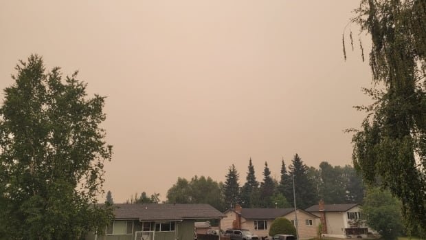

Residents in some parts of central and northern B.C. are being warned about the extremely poor air quality caused by the smoke from wildfires burning across the region.
According to the latest data from the B.C. government on Wednesday, Prince George and Quesnel have a score of "10+" on the air quality health index (AQHI), indicating that people living there and in the surrounding areas face high health risks due to air pollution.
A light white ash has been seeing falling from the sky in those cities, covering cars and buildings.
The B.C. Wildfire Service reports that more than two-thirds of the province's approximately 330 fires are burning in central and northern B.C.

At least 12 new evacuation orders or alerts have been issued over the last day in British Columbia as lightning storms and drought conditions add to the challenge of fighting hundreds of wildfires.
Flames are not threatening any large communities, but an additional evacuation order has been issued for the fire just east of the Village of Burns Lake on Wednesday, and evacuations are also posted for a number of properties outside Houston.
The Regional District of Bulkley-Nechako has issued 18 emergency alerts due to fires throughout the region, with seven of those being evacuation orders.
Late Wednesday, the district expanded evacuation orders and alerts for the out-of-control Parrot Lookout wildfire, which has grown to cover 42 square kilometres since it was first discovered on July 7. It also issued an evacuation order for properties on the east end of the Nechako Reservoir due to the Lucas Lake fire.
An evacuation alert means residents should prepare to evacuate their homes, possibly with little to no notice. An evacuation order means a resident should leave immediately.
The Cariboo Regional District in central B.C. has also issued multiple evacuation orders, with a new order covering 293 land parcels in the Teepee Lake area on Wednesday.
An evacuation order was also issued Wednesday by the Regional District of Fraser-Fort George for areas close to the Great Beaver Lake fire in Electoral Area G.
UPDATE: #Evacuation Order issued by Regional District of Fraser-Fort George for area of Great Beaver Lake, Teardrop Lake, Tureen Lake and Bugle Lake in Electoral Area G. More info: https://t.co/sRBPn1s9TQ
Anyone in the area is at risk and should leave immediately. #BCWildfire https://t.co/gQvoCbjrQ0 pic.twitter.com/I1ZsUYEVgO
—@EmergencyInfoBCCasda Thomas, a fire information officer with the B.C. Wildfire Service, said northwest B.C. was seeing an unprecedented amount of fire activity early into the wildfire season.
"To date, we have had 150 wildfires in the Northwest Fire Centre," she told CBC News. "This compares with our 10-year average of about 47."

Fort St. John in northeastern B.C., the closest city to the Donnie Creek wildfire, which has already burned over 580,000 hectares of land, has a score of "4" on the index.
The AQHI is an online health information communication tool developed by Health Canada. It assesses the severity of air pollution and how it can impact both the general population and at-risk groups, such as seniors, infants and individuals with heart or lung conditions, in the short term.
The index incorporates real-time levels of three common pollutants found in Canadian air: fine particulate matter, ground-level ozone and nitrogen dioxide.
Poor air quality could affect vulnerable people
In its air quality advisory on Tuesday, the British Columbia government emphasized that individuals with pre-existing health conditions, respiratory infections, seniors, children and pregnant people are more susceptible to the adverse effects of poor air quality.
The province recommends that the vulnerable population follow these guidelines:
- Reduce or cease physical activity if experiencing difficulty in breathing.
- Stay cool and stay hydrated by drinking plenty of water.
- Always carry any necessary rescue medications with you.
What's Your Reaction?